WhatsApp
 SMS - Text us!
 Email Us!
 Help Desk
- GPSMAP 64
- Lanyard
- USB cable
- Manual


Model Number: 010-N1199-00
Out of stock
 View full details
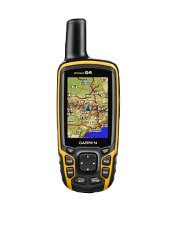
Embark on your next outdoor adventure with the Garmin GPSMAP 64, a robust handheld GPS device designed for trail enthusiasts and explorers alike. This Garmin Certified Refurbished model combines cutting-edge technology with user-friendly features to ensure you never lose your way.
With the Garmin GPSMAP 64, you can:
Lightweight and slim, the Garmin GPSMAP 64 is your ultimate companion for hiking, biking, and any outdoor activities. Navigate the great outdoors with ease and confidence, and make every adventure unforgettable.
Do you have an old GPS unit lying around? The GPS Nation Trade In and Up program is a great way to trade in your old and used GPS for credit towards a new GPS. The choice is entirely yours! We’ve made the process simple and streamlined. Follow these simple steps, and you will be on your way to receiving credit towards your brand new GPS!
To get your free quote, provide your GPS type, manufacturer, model, and condition. Within 24 hours, you will receive a quote for the trade-in value of your current product. The GPS trade-in/trade-up form is at the bottom of this page.
After accepting our offer, pack your product(s) safely and ship them to us using the pre-paid shipping label provided to you. We will provide a confirmation email when your trade-in arrives at our warehouse. You have 30 days from the date you complete your on-line trade to ship the product to GPS Nation.
Once we receive your product at our warehouse and we validate the stated condition, we will send you a confirmation email. If you elect to receive credit towards a new GPS at gpsnation.com, your store credit will be issued, and you are free to make your purchase.
Embark on your next outdoor adventure with the Garmin GPSMAP 64, a robust handheld GPS device designed for trail enthusiasts and explorers alike. This Garmin Certified Refurbished model combines cutting-edge technology with user-friendly features to ensure you never lose your way.
With the Garmin GPSMAP 64, you can:
Lightweight and slim, the Garmin GPSMAP 64 is your ultimate companion for hiking, biking, and any outdoor activities. Navigate the great outdoors with ease and confidence, and make every adventure unforgettable.

We want you to be confident that you'll get years of use out of every purchase from us. That’s why we offer both a free 2 year warranty, and additional options beyond.

We want to reward our most loyal customers by showing our loyalty back! Earn reward points with every purchase that you can use to earn more gear from GPS Nation!

We have a hassle-free return policy in place, meaning that we don't make you jump through hoops in order to return items for a refund or an exchange.

 Garmin Warranty